‘They will shoot you”. “Who will shoot me?” “The settlers will shoot you”- a conversation with an Israeli army (IDF) patrol shortly after I entered the West Bank at Meitar, the southern-most checkpoint.
A little while later, a similar conversation with the Israeli Border police at an internal checkpoint. ‘You can’t go there, they will shoot you.” “Who will shoot me?”. “The Palestinians will shoot you”. I’m still here and have never been shot having biked extensively in the West Bank.
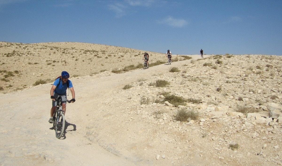
Safely biking the West Bank takes some thought, some local knowledge from people you trust, an eye on the security situation, and a friendly approach to everyone. You can do it alone or join a guided group from Bike Palestine, Green Olive Tours, and other organizations.
Alone has the advantage of being able to choose your own route and places to stay, while organized has the hassle-free, SAG-wagon advantage.
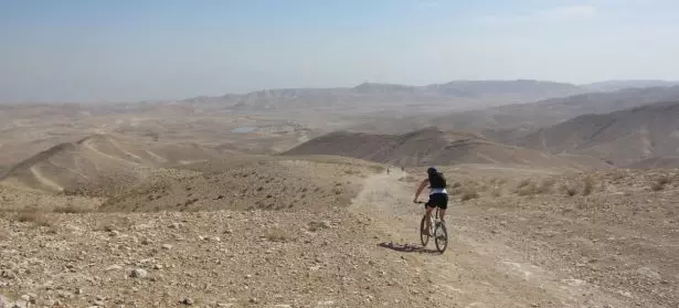
You can bikepack on very well made main roads, get off onto rural and village roads or, on a gravel bike or MTB, have some truly great rides on desert tracks down to the Dead Sea.
The WB is compact, only 130 km north to south, so it won’t take a lot of time to get to interesting places.
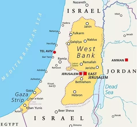
The landscape is rolling at best with some serious climbs in places. There are some places to avoid and definitely some places you must not miss.
Where to stay:
Do not camp in the WB; you will be vulnerable to theft and/or assault (from any side) and it is not safe. There are established hotels and an increasing number of homestays in Palestinian towns and villages.
The latter are usually family affairs and will let you meet Palestinians at home. The Palestinian tradition of hospitality is very real; expect a meaningful and memorable welcome.
Where to go:
I’m going to suggest a route with a couple of variations, but use any part of this to make your own. I’ll also suggest my highlight places.
My ride starts in the south, just north of the Israeli city of Be’er Sheva where Israeli Route 60 enters the WB. From the Meitar checkpoint you can bear left and follow a rural road that climbs steeply to Al Ramadin village then goes north along the west side of the WB, rolling to the steep country through Palestinian villages.
If you go this way you go through the village of Tarqumiya (just after you cross Route 35) and then follow a steep climb up to Hebron through a lovely wooded valley. You can go more directly to Hebron via Route 60 from Meitar, an easier ride on a wide shoulder but a much busier road.
Hebron is a highlight and worth staying for a day or so. Get a tour with “Breaking the Silence” around the center of the old city where Israeli settlements overlook the alleyways. The glassblowers are also worth a visit.
Route 60 goes north of Hebron directly to Bethlehem but you can also go east via a rural road through Sa’ir village, past Tuqua, and Tekoa (the first a Palestinian village, the second an Israeli settlement) and climb up to visit Herodian, King Herod’s summer hill-top palace.
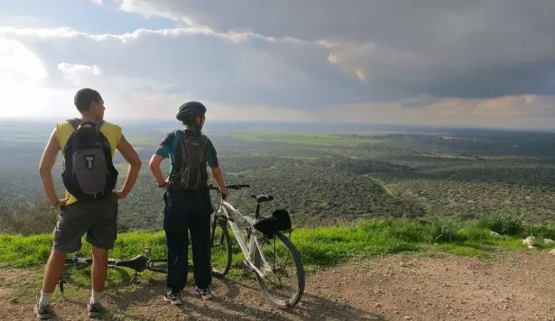
It’s worth it for the ruins, the underground water system, but also for the hilltop view that shows the occupation landscape of settlements, villages, and the cities of Bethlehem and Jerusalem. To the west, you can see the desert all the way to the Dead Sea.
It’s a short ride to Bethlehem from Herodian and Bethlehem is worth at least a day. There are plenty of places to stay, from a range of hotels, some fancy, some not; to Banksy’s “Walled Off” hotel, to homestays.
If you like traditional charcoal roasted chicken with pita, Arabic salad, and a truly addictive garlic dip, there is a tiny but wonderful place just beside the Post Office in Beit Jala, a 10-minute ride across the valley from Bethlehem. Just ask for Qabar or “Beit Jala Chicken”, everyone knows it. It literally is a hole in the wall.
But, focusing on biking, you have some choices from Bethlehem. If you want to go the 20 km or so into Jerusalem you can go via either at Gilo checkpoint at the south end of Bethlehem, past the “Walled Off’ (make sure to take the vehicle lane, Palestinians can only walkthrough and may direct you to the walking lane) which is unfriendly but shorter or take a ride through the country via the laid back Al Wallaja checkpoint.
If you want to see the occupation in action, check out the Bethlehem side of the walking lane at Gilo at 05:00 in the morning, where hundreds of workers are waiting to cross.
To stay in the WB you ride east of Bethlehem through Beit Sahur and up a long climb to the monastery of Mar Theodosius. Just below the monastery, the next village is Ubediya. Turn off right through the village and it is a 5 km descent to the monastery of Mar Saba located high on the side of the Kidron Valley.
Sometimes male visitors will be invited into this very old monastery, but that is rare, and women are not allowed in at all. But the ride and the setting are spectacular.
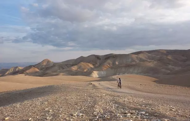
Here is where your gravel bike or MTB will let you take a desert road down to the Dead Sea. The first part is a Roman road and the original Roman cobbles are visible. There are a number of possible routes, the straightest is also the best surface, aim for the gas station at Almog.
If you’re not equipped for the dessert option, climb back up to Ubediya, continue north, and zoom down into Wadi Nar – the Valley of Fire – and up the steep climb out the other side. In summer this valley deserves its name. Take a right at a T-junction and drop down again on Route 417.
On the hill to the right will be the big settlement of Maale Adumim and Al Zaim village above on the left. There’s another, shallower climb before the long, swooping, wonderful drop to 300m below sea level at Almog: about 1km after the gas station turn left to Jericho.
Jericho sounds more intriguing than it is; one of the oldest cities in the world, it shows its age. However, there are several sites worth a visit so give it a day and seek out the little things that make any town interesting. If you like ruins, Herod’s winter palace – he was a great builder – is on the western side of town.
Do you like beer? You will feel like having more than one at Taybeh village. There’s a long, grunty climb out of the Jordan Valley to this village on a ridge above. Definitely stay here – you’ll need it after the ride up, and the sunset over Jordan and the Dead Sea from one of the restaurant terraces is well worth it.
Taybeh is home to the only brewery in the WB, making Belgian style beers, and also a winery that uses local grapes. It’s a clean and professional family enterprise started by the Khoury brothers and continued now by the next generation.
Taybeh itself is interesting as a Christian village in the largely Muslim WB with Greek Orthodox, Eastern Catholic, and Episcopalian churches and a crusader fortress. They even have an Oktoberfest.
Two stops to go. From Taybeh it’s a few hours to Road 60 and north into Nablus. An old roman city Neopolis, Arabised as Nablus, holds a wonderful old city.
Due to the occupation, it is largely unspoiled by tourism and the little alleyways and narrow streets, hole in the wall shops, and the ancient mosque, originally a Crusader-era church, make Nablus old city my favorite place in the WB. Spend a day here before heading a few hours north to Sebastiya.
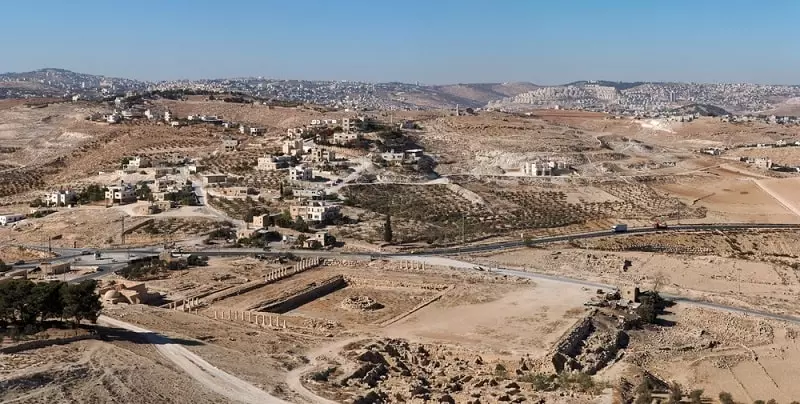
This very old village is making the best of its position on the edge of an archaeological site that dates from the Iron Age, with the Bronze Age, Helenic, and Roman layers. Of course, this is the WB, so control of the site is contested between the Antiquities Authority of the PA and its Israeli equivalent.
This won’t spoil your visit but you’ll see evidence of both. There are really comfortable homestays and hostels and some interesting Crusader-era remains in the village itself.
A long day will take you north on Road 60 to Jenin through rolling farm country and small towns. A little-visited spot is the village of Burqin just to the west of Jenin. It’s a short ride from Route 60 (turn left at the signpost from Al Shahada cross-roads about 5km south of Jenin ) and is the site of a tiny Byzantine-era church (St. George’s).
The church is partly built in a cave and is said to the third oldest in the world. You can stay in a homestay here, or in Jenin. Burquin, sometimes spelled Burkin, has an active women’s collective making local products, and the very modern Canaan Fair Trade factory just out of town converts local almonds, olives, and other items into high quality products.
Leave the WB at Al Jalameh checkpoint just north of Jenin. If you are still committed to things biblical and have the time, Nazareth is about 70km north of Al Jalameh.
Places to avoid and security:
The population of smaller Israeli settlements, especially near Nablus or those that look semi-temporary, are often militant, armed, and dangerous. Even the IDF is afraid of them. Avoid these.
Don’t hang about near any military base or site, they’re not dangerous to bike past, but just keep moving. Same with checkpoints, once you’re through, quietly move away and don’t take photos.
You can cross between the West Bank and Israel at many points along the wall. Crossing checkpoints are usually fine if you follow a few guidelines. Approach slowly, make eye contact with the soldiers as you approach, have your passport handy, and be friendly.
You may have your own views on the IDF but the 18-19-year-old conscripts are ill-disciplined, usually bored, a bit scared, and generally have a cartoon-like view of Palestinians.
You will be a mystery to them – someone who is ‘risking your life’ relating to Palestinians. Behave aggressively or arrogantly and you’ll probably get the same back; help them relax a bit and you may even have a conversation and learn something.
Leave your dumb behind: never ever, not once, not at all try and joke about security, weapons, bombs, terrorism, or similar.
If there is a civil disturbance like a demonstration or a Palestinian being arrested, keep on pedaling. It’s tempting to feel that, being a foreigner, you have some sort of immunity in situations like that.
Your foreign passport will count for nothing, it may even make you a target of extra IDF or PA Security force attention if you are perceived to be a foreign trouble maker. You won’t be able to help and may escalate the situation.
Palestinians are no better or worse than other relatively poor populations when it comes to theft. No need to be paranoid but take all the usual precautions with your bike and gear. I locked my bike outside a house in Beit Jala once to come back to a stripped frame a few hours later, but that only happened once.
Maps and info
All maps are political in some way, and information comes from people with their own views. An Israeli road map will show settlements and the main roads, with little reference to Palestinian towns and cities.
Palestinian maps have the inverse, so treat all local maps with skepticism and cross-check. The UN Office for the Coordination of Humanitarian Affairs has great interactive maps that show checkpoints, roadblocks, and other occupation restrictions (it is also a very good source for fairly balanced information on the conflict).
GPS is just as political – in Waze you must select for “High risk” places in your settings otherwise it won’t let you go into Palestinian controlled areas. Google maps is limited too. Open-source maps such as Map.me and OpenStreet map are better but not to be totally relied on.
Garmin advertises their Israel topo map as featuring ‘coverage for all of Israel, including the territories of the Gaza Strip and the West Bank’ which may reflect the politics of what it will show.
For all GPS systems there is the ambiguity inherent in transliterating Arabic or Hebrew place names to English; check the GPS route against a paper map, it is easy to head toward a town with a similar sounding name but in totally the wrong direction.
For desert travel in the WB, the Israeli Jewish National Fund (KKL-JNF) has detailed 1:50,000 topo maps where each trail is color-coded on the map with matching paint marks on rocks at junctions and along the route.
You can plan your route and navigate by the colors. These maps are in Hebrew but by matching the place names from a map in your own language and writing them on the KKL-JNF map, you can easily use them. They can be bought in most major bookshops in Israel.
When I’m out in the countryside I make a point of asking locals I meet – shepherds, kids walking to school, etc – to confirm my route, even if I’m pretty sure I’m on track. Confirmation is always good, it establishes you are not Israeli, and you can have a nice conversation. Be prepared to be invited into someone’s home.
It’s complicated:
The WB is a complicated; long and complicated history, complicated politics, complicated passions. You can leave your confirmation bias in place and you’ll have all your preconceptions confirmed but, if you leave your preconceptions behind, and come prepared to really listen, you’ll learn a whole lot.
Don’t expect to understand it all. Anyone who says they understand the WB situation just doesn’t get it. It’s the complexity that is so appealing.
Images: Tim Williams, Depositphotos

Tim Williams is a New Zealander with a passion for bikes and for maps. He has toured in the Middle East, in New Zealand, SE Asia, and in the eastern USA where he now lives. He spent 10 years in the Middle East mostly in Israel and Palestine (both West Bank and Gaza) working for NGOs and UN agencies.

